H11
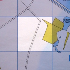
Swanpool
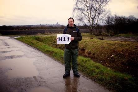

H11
Swanpool
This week we visit an peaceful, empty field in the Swanpool area - but empty for how long? This area is earmarked for an "urban extension" so the bulldozers could be moving in shortly. Meanwhile, the discovery of Haw Hill in the grid leads producer Jonny Haw to muse over whether this area is his birthright he should declare an independent state, while Paul tries to temper his dictatorial tendancies. And we stumble over our best object yet: some spent gun cartridges. But what are those banging sounds we can hear in the distance....?
Click on the player below to listen to the podcast, or subscribe to our iTunes feed using the button on the right...


ABOUT LINCOLN ATOZ


FOLLOW US ONLINE:

LISTEN TO US LIVE!
EVERY MONDAY
9PM-10.30PM ON
HOW
YOU
CAN GET
INVOLVED!


EXPLORE
THE MAP


The History of H11
by Joanna Hughes of the Lincolnshire Archives
At first glance this grid square doesn’t seem to look very promising but a little bit of delving reveals just how much history can be contained in one small seemingly featureless area.
Food and Fuel
Before this land was drained in recent centuries and turned it into fields, this was a low-lying area, with the Fossdyke and Brayford Pool to the north and the River Witham on the east. It would have been affected by the fluctuating water levels (it’s interesting to think that, as inland as Lincoln is, even the Brayford Pool may once have been affected by the rise and fall of the tides). The land would often be flooded and when the waters went down it would be left as woodland and squelchy fen, dotted with small pools. It was this very water logged and woody nature which made the landscape here such an important resource for early people. Even before the Romans and well into the medieval period there’s evidence to show that this area was extensively exploited, providing early inhabitants with vital supplies: peat and firewood for fuel, timber for construction, reeds for making baskets and fish traps and arable land to graze pigs on.
Ducks and decoys
As well as fish, this wetland provided the early citizens of Lincoln with plenty of water fowl such as duck, geese and swan – this is no doubt how Swanpool gets its name. It’s been suggested that the Swanpool, (now the name of an area but originally referring to the small body of water still visible on a map) rather than originating as a peat cutting, may have been created as a decoy. There’s still the remains of a Duck Decoy, a scheduled ancient monument northwest of here, near the Skellingthorpe roundabout on the A46 by-pass. This was created centuries ago to farm water birds for Lincoln’s hungry citizens. Wild duck were led down pipes by tame decoy ducks and driven into nets by terriers! Archaeologists have found that the early Lincoln diet included a lot of fish and fowl. Interestingly, on an early map of 1779 at the Lincolnshire Archives there is also a pool in this area called Cuckoo Pool (although I don’t remember cuckoos being water birds!).
Rites and Rituals
Part of this area is a wide old valley formed by the Prial Brook, now called Prial Drain, which runs under Doddington Road, through the lakes at Hartsholme Park and on to this area of our grid square, which is referred to on old maps at the Lincolnshire Archives as “The Holmes” or “Holmes Common”. This name is quite interesting as a “holm” can refer to both flat land near a river but more commonly a low island in a river or lake. This is where it gets interesting, as on some old maps there is a raised area of land called “Haw Hill”, presumably named after the hawthorn trees which would have grown around here. Imagine this area after the water level had risen and flooded the land – it would really have appeared as a small island in a glassy wetland. Iron Age people would have given great importance to such a significant feature in an otherwise flat landscape and it’s highly probable it would have had some pagan ritualistic function.
Who knows, there may still be well-preserved archaeology beneath the peaty soil in this relatively unexplored area, perhaps votive offerings like the Witham Shield found in the Witham at Fiskerton, thrown into the murky fens to appease the ancient water gods….In later centuries it could have maintained its spiritual importance as there is evidence to suggest that Haw Hill may have been the site of a small monastic house in early medieval times, possibly even a hospital. Archaeological finds on top of this small hill have included building materials, medieval pottery and tiles, remains of shellfish, refuse and charcoal. Was this really the site of the documented “Hospital of St Mary Magdelene in Hartsholme” founded in the 12th century by Ranulf Earl of Chester and passed to Bardney Abbey, where King Edward II sent one of his servants to be cared for by the monks?….Was this an even earlier island site of pagan worship, mysteriously rising above a glassy lake that appeared and disappeared with the tides? Is this Lincoln’s own Glastonbury Tor in miniature?? (Speaking of the Witham Shield, don’t forget to go and see it at The Collection in Lincoln on loan from The British Museum until 9th June 2013).
(C) 2013 Lincoln AtoZ | Contact us