The History of L16
by Joanna Hughes of the Lincolnshire Archives
Bracebridge is referred to as “Brachebrige” in Domesday Book (1086) and scholars have had quite a time of trying to deduce the origin of the name. The English Dialect Dictionary suggests “braesc” is related to various Scandinavian words for small branches, twigs and etc. The tentative conclusion is that it derives from the construction of an early brushwood causeway or bridge (“brige”) at this point over the River Witham. This might suggest it was the easiest point at which River Witham could be crossed (it would have been much wider hundreds of years ago, and the riverside any nearer the city was swampy or liable to flood). It also explains the kink in an otherwise fairly straight road from Leicester and the southwest.
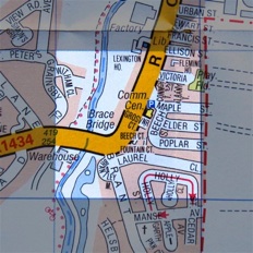
This area of Bracebridge grew up around an important crossing point of the River Witham by the ancient trackway known as the Fosseway, the Roman military road from Exeter to Lincoln. The parish of Bracebridge lay outside the city, with the old parish church of All Saints just south of the Witham crossing on Brant Road, previously known as Brant Lane. Interestingly, the line of this end of Brant Road was quite different to today – the parish map of 1842 shows original northern portion of Brant Road cutting through fields, with All Saints Church and graveyard on left with The Manse, the building where the vicar would have lived, on the east side.
Brant Lane is probably medieval in origin. It helped bring business and prosperity to Lincoln from the farmlands south of Lincoln in the Witham Valley. It would also have provided a useful alternative to Newark Road in providing access to the Great North Road at Marston near Grantham. This would have been especially useful to the drovers herding their livestock along the roads to Lincoln’s slaughterhouses and meat markets (driving livestock being the best way of ensuring the freshest meat before the advent of refrigerated transport!). Brant Road allowed the drovers to avoid paying the tolls required by travellers, to travel along Newark Road.
The north end of Brant Road changed with the construction of Bracebridge Hall, known as Grosvenor Hall, (built on the site of an earlier house,) when the formation of the new Victorian hall’s parkland changed the road layout forever. A deed in the Hill deposit, held at the Archives, includes a plan of the new estate, which was bounded on the east side by the Lincoln and Honington Branch Railway…the Hall’s ornamental fishponds on the west side, (still visible today)….and on the north side by Maple street. The original Brant Lane joined High Street near the pub called The Gate House but was diverted to its current course when the Hall estate was built. The pub may be named after one of the lodge houses which let into the Hall’s parkland. The other lodge house to the old Hall can still be seen on the corner of Brant Road and Newark Road.
The Lincoln and Honington Railway opened in 1867 and ran until 1965 when, like so many others in Lincolnshire, it was decommissioned during the Beeching cuts. It was built to serve the cliff villages like Waddington and Navenby as well as Grantham, and to provide a possible alternative route to London. Like the medieval Brant Lane before it, it would have helped develop Lincoln’s role as a commercial centre. Nothing remains apart from the “ghost” of this line at the foot of the Lincoln Ridge, along with railway bridges and station houses along its route, long since turned into homes.
After the railways, but before the arrival of motor cars, Lincoln still relied on the centuries-old system of horse power, but this changed to some degree when Lincoln City constructed its one and only tramline in the late nineteenth century which terminated in Bracebridge. The arrival of motor buses and cars eventually took over from the tram system in the early twentieth century.
You can see how, with Newark Road as major route into the city, dating from Roman times (probably earlier), its bridge, the River Witham itself, the intersection with Brant Road, the Lincoln and Honington Railway, the city tramways and the buses, the area covered in this grid square has played an important part in the growth of Lincoln City, due in no small part to its situation. It’s been at the hub of many different transport systems over the centuries, changing Bracebridge from a quiet rural village to an important suburb, acting as an major gateway to the city from earliest times, welcoming Roman soldiers, farmers and statesmen, drovers and businessmen, Victorian industrialists, pleasure-seekers and shoppers alike into the city.